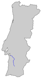
 The Sado is born at an altitude of 230 m in Serra da Vigia and flows 180 km until it flows into the Atlantic Ocean via the Setubal Bay (one of the most beautiful bays in the world).
Downstream of Alcácer do Sal to the rivermouth there develops a large estuary (estuary of the Sado) which is separated from the ocean by the Tróia peninsula. It is one of the few Portuguese rivers that runs from South to North, like the Mira River in Odemira.
A pod of dolphins inhabits (Roazes-Corvineiros) in the Sado estuary.
The Sado river basin has an area of 7,692km² which fully risides on Portuguese soil. The estuary has an area of approximately 160 km² with an average depth of 8m, the maximum being 50m. The flow is forced mainly by tide.